 vesseltracker.com
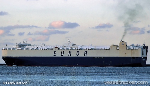
Vessel MORNING LADY IMO: 9445980, MMSI: 441467000 Vehicles Carrier
UTC, 35.52500, 129.38834, course: -1, speed: 0
UTC, 35.52500, 129.38834, course: -1, speed: 0
2026-03-01 05:16:23 UTC, 35.52500, 129.38834, course: -1, speed: 0
Live AIS position:
UTC. Near Mipo/Ulsan),
updated 2026-03-01 05:16:23 UTC.
Find the position of the vessel MORNING LADY on the map. The latter are known coordinates and path.
marine traffic ship tracker show on live map
The current position of vessel MORNING LADY is 35.52500 lat / 129.38834 lng. Updated: 2026-03-01 05:16:23 UTCCurrently sailing under the flag of Korea (Republic of)
MORNING LADY built in 2010 year
Deadweight:
27343 tDetails:
Last coordinates of the vessel:
UTC, 35.52500, 129.38834, course: -1, speed: 0UTC, 35.52500, 129.38834, course: -1, speed: 0
UTC, 35.52500, 129.38834, course: -1, speed: 0
2026-03-01 05:16:23 UTC, 35.52500, 129.38834, course: -1, speed: 0